Kananaskis Country map
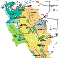
Regional overview map of Kananaskis Country from Alberta Parks, showing major parks, highways, day use areas, and key landmarks along the front ranges of the Rockies.
Local Info
Canmore • Kananaskis Village • Bragg Creek • Around Kananaskis
Find official maps for Kananaskis Country, Canmore, Banff National Park, and the Canadian Rockies. Use these resources to get oriented, understand distances, and plan safe routes for your trip.
Instead of relying only on static PDFs, this page links to up to date map resources from park agencies and local authorities, and also includes a few legacy PDF maps from Kananaskis.com for general reference. These official sources are updated more frequently and often include additional context like trail descriptions, regulations, and seasonal notices.
Use these maps along with current trail reports and weather forecasts so you can plan routes that match your experience level, available time, and the conditions on the day of your trip.
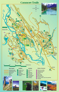
Area maps
Start with these regional maps to get an overview of Kananaskis Country, the town of Canmore, Banff National Park, and the wider Alberta and Canadian Rockies region.
Regional overview map of Kananaskis Country from Alberta Parks, showing major parks, highways, day use areas, and key landmarks along the front ranges of the Rockies.
Official Parks Canada maps and brochures for Banff National Park, including town maps, transit, campgrounds, and activity guides.
Official Town of Canmore Interactive Community Map with streets, neighbourhoods, parks, trails, land use, and other local GIS information.
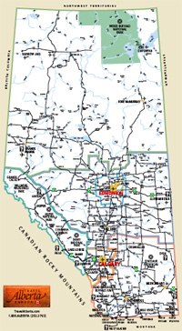
Province-wide maps and travel resources from Travel Alberta, useful when planning routes to and from Kananaskis Country and Canmore.
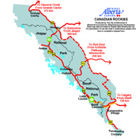
Overview map of the Canadian Rockies that places Kananaskis, Canmore, Banff, Lake Louise, and nearby ranges in a broader regional context.
Detailed Canadian Rockies hiking and driving maps from Gem Trek, a commercial map publisher covering Banff, Jasper, Kananaskis and other popular regions.
Trail maps
Use these resources for trail networks and route planning. Always pair them with up to date trail reports and avalanche forecasts where applicable.
Alberta Parks library of downloadable trail and area maps for Kananaskis Country, including valleys, campgrounds, day use areas and backcountry routes, plus many geo‑referenced PDFs for use with the Avenza Maps app.
Trails and pathways information from the Town of Canmore, with local routes for walking and cycling close to town.
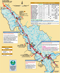
Parks Canada hiking information and downloadable maps for the Lake Louise area, useful if you combine Kananaskis outings with time in the national park.
Printable maps (PDF)
These PDF maps have been popular on Kananaskis.com for many years. They are helpful for a general overview or printing a simple map, but they may not reflect current roads, facilities, or park boundaries, so use them for general orientation only and follow the official maps above for current details.
Safety & disclaimer
Maps are planning tools, not guarantees. Conditions on the ground can change quickly due to weather, terrain, or seasonal closures.
The information we provide about routes and activities is for general information only and is not intended as specific advice. The writer and publisher of this website are not responsible for any accidents, injuries, rescues, inconvenience, or loss of life related to activities described here or on linked resources.
It is your responsibility to use common sense and good judgment when planning and undertaking any outdoor activity.
Activities in the backcountry involve hazards such as steep terrain, loose rock, changing snow and ice, fast moving water, and wildlife. Weather, visibility, and trail conditions can shift over the course of a single outing.
Each individual must understand their own limits, abilities, and level of expertise before attempting any route. When in doubt, choose conservative objectives or consider hiring a certified guide.
Next steps
Once you have found the maps you need, you can refine your plans with current conditions, activity ideas, and logistics for your visit.
Links to trail condition reports, trail information, and facilities for Kananaskis Country, Canmore, Banff National Park, and surrounding areas.
Check trail reportsLearn about local climate patterns and find links to current weather forecasts, warnings, and conditions for Kananaskis & area.
View weather informationFind transportation options, groceries and supplies, fuel and EV charging, vacation planning services, gear rentals, and more for your visit to Kananaskis and the Bow Valley.
Go to Plan Your Trip